Trevi → Poreta
Walking distance 12.1 km
Download Appy for the stage map
Stage information
- Ascent
- 501 m
- Descent
- 579 m
Difficulty: moderate
Walking the stage
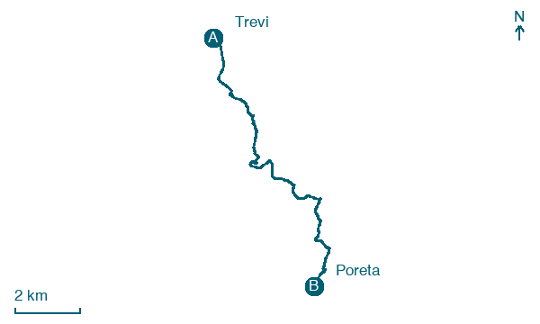
Walk 12 km from Trevi to Poreta with 501 m of climbing, passing Campello sul Clitunno and Borgo Lizori.
Before leaving Trevi, locate Chiesa di Sant'Egidio on the map. It is close to the starting point.
Look for these places on the stage map: Campello sul Clitunno, Borgo Lizori, Fontanelle, and Carvello.
What to see on this stage
History and landmarks
Chiesa di San Michele Arcangelo
Church · 300 m from the trail as the crow flies
building with a rectangular shape featuring perimeter walls made of cut stone with regular courses and a facade with very large squared reused blocks. Only the facade and part of the left nave are of Roman origin
Chiesa di Sant'Egidio
Church · 800 m from the trail as the crow flies
A rectangular building with perimeter walls made of regular coursed stone featuring large blocks from the Roman era used to reinforce the corners. The roof is partly barrel-vaulted and partly trussed.
Nature and landscape
Olivo di Alvanischio, Trevi
Monumental tree · < 100 m from the trail as the crow flies
Italy’s monumental tree register identifies this specimen as Olea europaea L. It records a height of 4.9 m and a trunk circumference of 45 cm.
Olivo di Ara - Via Giacomo Puccini, Trevi
Monumental tree · 400 m from the trail as the crow flies
Italy’s monumental tree register identifies this specimen as Olea europaea L. It records a height of 9 m and a trunk circumference of 210 cm.
Map · Trevi → Poreta
Take your walk with you: download Appy
Via di Francesco di Roma: Trevi → Poreta. Explore maps, stages and elevation in the app, and plan your train or bus journey.

