Citerna → Città di Castello
Walking distance 19.9 km
Download Appy for the stage map
Stage information
- Ascent
- 564 m
- Descent
- 742 m
Difficulty: moderate
Walking the stage
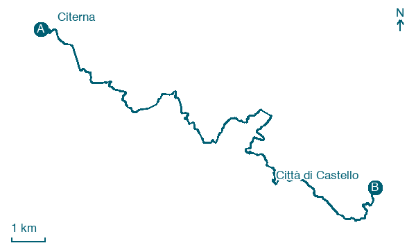
Cover 20 km from Citerna to Città di Castello, climbing 564 m, passing Monterchi and Abbadia.
Before leaving Citerna, locate Parco, commemorativo/ai caduti della Prima Guerra Mondiale on the map. It is close to the starting point. On arrival in Città di Castello, consider a stop at Ippocastano di Piazza Gabriotti, Città di Castello, close to the finish.
Look for these places on the stage map: Monterchi, Mezzavia, Uppiano, and Cinquevie.
What to see on this stage
History and landmarks
Parco, commemorativo/ai caduti della Prima Guerra Mondiale
300 m from the trail as the crow flies
The park is located on a small hill west of the inhabited center. Characterized by cypress trees arranged along the edges of the small hill.
Parco della Rimembranza
300 m from the trail as the crow flies
Memorial park for the fallen in the First and Second World Wars.
Nature and landscape
Ippocastano di Piazza Gabriotti, Città di Castello
Monumental tree · < 100 m from the trail as the crow flies
Italy’s monumental tree register identifies this specimen as Aesculus hippocastanum L. It records a height of 20 m and a trunk circumference of 404 cm.
Cedro dell'Atlante di Villa Montesca, Città di Castello
Monumental tree · 300 m from the trail as the crow flies
Italy’s monumental tree register identifies this specimen as Cedrus atlantica (Endl.) Manetti ex Carriere. It records a height of 30 m and a trunk circumference of 370 cm.
Map · Citerna → Città di Castello
Take your walk with you: download Appy
Via di Francesco di Roma: Citerna → Città di Castello. Explore maps, stages and elevation in the app, and plan your train or bus journey.

