Soriano Calabro → Mongiana
Walking distance 23.1 km
Download Appy for the stage map
Stage information
- Ascent
- 1455 m
- Descent
- 810 m
Difficulty: challenging
Walking the stage
The big climb through the Serre mountains via Croce Ferrata, the Eremo di Santa Maria del Bosco, and the famous Certosa di Serra San Bruno to the Bourbon ironworks town of Mongiana.
Before leaving Soriano Calabro, locate Soriano Calabro on the map. It is close to the starting point. On arrival in Mongiana, consider a stop at Mongiana, close to the finish.
Look for these places on the stage map: Pizzoni, Croceferrata, Serra San Bruno, and Ninfo.
What to see on this stage
History and landmarks
Soriano Calabro
< 100 m from the trail as the crow flies
Mongiana
< 100 m from the trail as the crow flies
Nature and landscape
Abete bianco di Santa Maria del Bosco, Serra San Bruno
Monumental tree · < 100 m from the trail as the crow flies
Italy’s monumental tree register identifies this specimen as Abies alba Mill. It records a height of 33 m and a trunk circumference of 390 cm.
Tasso di Castagnara, Serra San Bruno
Monumental tree · 100 m from the trail as the crow flies
Italy’s monumental tree register identifies this specimen as Taxus baccata L. It records a height of 20 m and a trunk circumference of 250 cm.
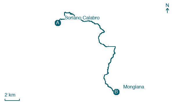
Map · Soriano Calabro → Mongiana
Take your walk with you: download Appy
Cammino del Normanno: Soriano Calabro → Mongiana. Explore maps, stages and elevation in the app, and plan your train or bus journey.

