Acquapendente → Bolsena
Walking distance 22.8 km
Download Appy for the stage map
Stage information
- Ascent
- 442 m
- Descent
- 508 m
Difficulty: moderate
Walking the stage
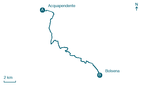
Cover 23 km from Acquapendente to Bolsena, climbing 442 m, passing San Lorenzo Nuovo, a full day on foot.
Before leaving Acquapendente, locate Cerro di Madonnina, Acquapendente on the map. It is close to the starting point. On arrival in Bolsena, consider a stop at Villa, struttura abitativa, close to the finish.
Look for these places on the stage map: San Lorenzo Nuovo.
What to see on this stage
History and landmarks
Villa, struttura abitativa
Palace · < 100 m from the trail as the crow flies
The area of Mercatello occupies a portion of the homonymous promontory that slopes down towards the lake and the current town. The area is roughly divided into about 3 blocks delimited by kardines and decumani sometimes paved.
Archaeological Area of Volsinii
Museum · < 100 m from the trail as the crow flies
The Archaeological Area of Volsinii is a museum in Bolsena, Italy, designated as Italian national heritage, covering 40,000.0 km².
Nature and landscape
Cerro-sughera di Campo Moro, Acquapendente
Monumental tree · < 100 m from the trail as the crow flies
Italy’s monumental tree register identifies this specimen as Quercus crenata Lam. It records a height of 15 m and a trunk circumference of 400 cm.
Cerro di Madonnina, Acquapendente
Monumental tree · 200 m from the trail as the crow flies
Italy’s monumental tree register identifies this specimen as Quercus cerris L. It records a height of 20 m and a trunk circumference of 240 cm.
Map · Acquapendente → Bolsena
Take your walk with you: download Appy
Romea Strata Italiana: Acquapendente → Bolsena. Explore maps, stages and elevation in the app, and plan your train or bus journey.

