Tiglieto → Arenzano
Walking distance 28.9 km
Download Appy for the stage map
Stage information
- Ascent
- 874 m
- Descent
- 1310 m
Difficulty: challenging
Walking the stage
Tackle a demanding 29 km stage from Tiglieto to Arenzano, with 874 m of climbing on the way, passing through Bianchina and Acquabianca.
Before leaving Tiglieto, locate Ponte medioevale sul torrente Orba on the map. It is close to the starting point.
Look for these places on the stage map: Bianchina, Acquabianca, Sambuco, and Cantarena.
What to see on this stage
History and landmarks
Ponte medioevale sul torrente Orba
Bridge · < 100 m from the trail as the crow flies
17th-century bridge, in Tiglieto, Italy, built in stone.
Tiglieto Abbey
Abbey · 400 m from the trail as the crow flies
Founded on 18 October 1120 by monks from La Ferté in France, it was the first Cistercian community in Italy and the first outside France. The architecture is close to the French style, and the monks farmed the valley and looked after its woods.
Nature and landscape
Rovere di Ponte Medievale, Tiglieto
Monumental tree · < 100 m from the trail as the crow flies
Italy’s monumental tree register identifies this specimen as Quercus petraea (Matt.) Liebl. It records a height of 15 m and a trunk circumference of 460 cm.
Tasso di Gattazze', Urbe
Monumental tree · < 100 m from the trail as the crow flies
Italy’s monumental tree register identifies this specimen as Taxus baccata L. It records a height of 15 m and a trunk circumference of 320 cm.
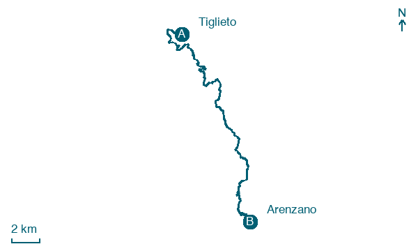
Map · Tiglieto → Arenzano
Take your walk with you: download Appy
Cammino dei Santuari del Mare: Tiglieto → Arenzano. Explore maps, stages and elevation in the app, and plan your train or bus journey.

