Arenzano → Genova
Walking distance 16 km
Download Appy for the stage map
Stage information
- Ascent
- 570 m
- Descent
- 433 m
Difficulty: moderate
Walking the stage
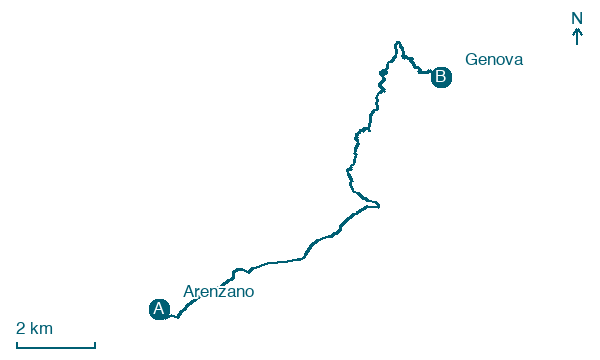
Walk 16 km from Arenzano to Genova, with 570 m of climbing along the way, passing through Terrarossa and Vesima.
Before leaving Arenzano, locate Arenzano Memorial Avenue to the Fallen of All Wars on the map. It is close to the starting point. On arrival in Genova, consider a stop at Nostra Signora dell'Acquasanta Sanctuary, close to the finish.
Look for these places on the stage map: Terrarossa, Vesima, Mele, and Biscaccia.
What to see on this stage
History and landmarks
Nostra Signora dell'Acquasanta Sanctuary
< 100 m from the trail as the crow flies
17th-century sanctuary in baroque style, in Genoa, Italy.
Arenzano Memorial Avenue to the Fallen of All Wars
< 100 m from the trail as the crow flies
The Memorial Avenue is located in the center of Arenzano, connecting the more historic part with the expansion area that developed around the Sanctuary.
Nature and landscape
Sequoia sempreverde di Via Acquasanta Presso Civico 275, Genova
Monumental tree · < 100 m from the trail as the crow flies
Italy’s monumental tree register identifies this specimen as Sequoia sempervirens (D. Don) Endl. It records a height of 40 m and a trunk circumference of 435 cm.
Cedro del Libano di Piazza Chiesa Acquasanta Presso Civico 107, Genova
Monumental tree · < 100 m from the trail as the crow flies
Italy’s monumental tree register identifies this specimen as Cedrus libani A.Richard. It records a height of 25 m and a trunk circumference of 461 cm.
Map · Arenzano → Genova
Take your walk with you: download Appy
Cammino dei Santuari del Mare: Arenzano → Genova. Explore maps, stages and elevation in the app, and plan your train or bus journey.

