Villacidro → Monti Mannu
Walking distance 18.1 km
Download Appy for the stage map
Stage information
- Ascent
- 371 m
- Descent
- 291 m
Difficulty: moderate
Walking the stage
From Villacidro, this walk of about 18 km follows the right bank of the lake and the Rio Leni before a steep climb from the church of San Sisinnio up to the Cariatzu road. It ends at the Monti Mannu plant nursery, where the nearby Posada guesthouse is the only place with wifi.
Before leaving Villacidro, locate Church of Saint Barbara on the map. It is close to the starting point.
What to see on this stage
History and landmarks
Church of Saint Barbara
Church · < 100 m from the trail as the crow flies
Church in baroque style, dedicated to Saint Barbara, in Villacidro, Italy.
Casa
100 m from the trail as the crow flies
The small palace, due to its location overlooking Piazza Zampillo and adjacent to the former Monte Granatico, for its use as a literary café and the architectural quality it still possesses, represents a rare example of successful urban recovery.
Nature and landscape
Olivastro di Chiesa di San Sisinnio, Villacidro
Monumental tree · < 100 m from the trail as the crow flies
Italy’s monumental tree register identifies this specimen as Olea europaea subsp. oleaster (Hoffmanns. & Link). It records a height of 10 m and a trunk circumference of 780 cm.
Fillirea di Canale Serci - Canali S'Otti, Villacidro
Monumental tree · 300 m from the trail as the crow flies
Italy’s monumental tree register identifies this specimen as Phillyrea latifolia L. It records a height of 7 m and a trunk circumference of 250 cm.
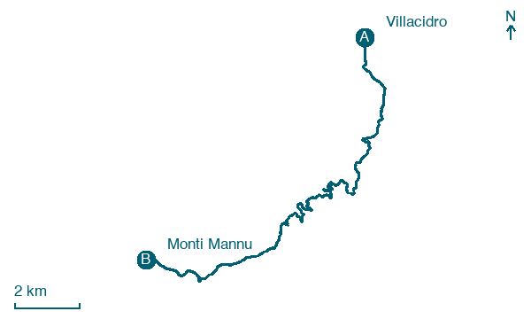
Map · Villacidro → Monti Mannu
Take your walk with you: download Appy
Cammino Minerario di Santa Barbara: Villacidro → Monti Mannu. Explore maps, stages and elevation in the app, and plan your train or bus journey.

