Colle del Gran San Bernardo → Échevennoz
Walking distance 14.9 km
Download Appy for the stage map
Stage information
- Ascent
- 158 m
- Descent
- 1411 m
Difficulty: moderate
Walking the stage
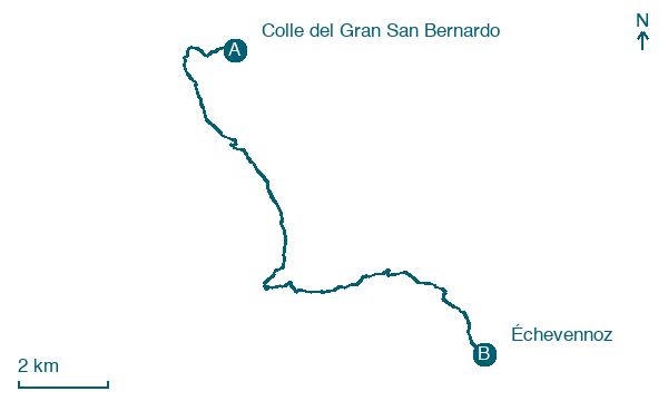
Follow a 15 km stage from Colle del Gran San Bernardo to Échevennoz, with 158 m of climbing on the way.
Before leaving Colle del Gran San Bernardo, locate Grande Chenalette on the map. It is close to the starting point.
Look for these places on the stage map: Fontintes, Saint-Rhémy, La Vagère, and Pallais-Dessous.
What to see on this stage
History and landmarks
Vachéry Tower
Tower · 400 m from the trail as the crow flies
Tower, in Étroubles, Italy, designated as Italian national heritage.
Grande Chenalette
700 m from the trail as the crow flies
Natural landmark, in Entremont District, Switzerland, at 2,852 m elevation.
Nature and landscape
Maggiociondolo alpino di Chateau Verdun - Via Flassin 3, Saint-Oyen
Monumental tree · < 100 m from the trail as the crow flies
Italy’s monumental tree register identifies this specimen as Laburnum alpinum (Mill.) Bercht. & J. Presl. It records a height of 7 m and a trunk circumference of 305 cm.
Great St Bernard Lake
Lake · < 100 m from the trail as the crow flies
Map · Colle del Gran San Bernardo → Échevennoz
Take your walk with you: download Appy
Via Francigena: Colle del Gran San Bernardo → Échevennoz. Explore maps, stages and elevation in the app, and plan your train or bus journey.

