Châtillon → Verrès
Walking distance 19.2 km
Download Appy for the stage map
Stage information
- Ascent
- 634 m
- Descent
- 814 m
Difficulty: moderate
Walking the stage
Climb 634 m over 19 km from Châtillon to Verrès, a demanding stage with a steady ascent, passing through Barmusse and Violan.
Before leaving Châtillon, locate Castello Passerin d’Entrèves on the map. It is close to the starting point.
Look for these places on the stage map: Barmusse, Cillian, Le Creston, and Couassod.
What to see on this stage
History and landmarks
Castello Passerin d’Entrèves
Castle · 100 m from the trail as the crow flies
Castle, in Châtillon, Italy, designated as Italian national heritage.
Néran tower
Tower · 100 m from the trail as the crow flies
Tower, in Châtillon, Italy, designated as Italian national heritage.
Nature and landscape
Riserva naturale Lago di Villa
National park · 1.1 km from the trail as the crow flies
A small lake in a wooded glacial hollow, with white water lilies and sedges along the edge. It is an important breeding site for many amphibians, and an easy walk leads to it.
Faggio rosso di Via Gervasone - Parco del Castello Passerin D'Entrèves, Chatillon
Monumental tree · < 100 m from the trail as the crow flies
Italy’s monumental tree register identifies this specimen as Fagus sylvatica L. var. `purpurea`. It records a height of 21 m and a trunk circumference of 380 cm.
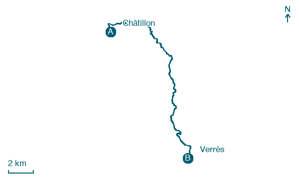
Map · Châtillon → Verrès
Take your walk with you: download Appy
Via Francigena: Châtillon → Verrès. Explore maps, stages and elevation in the app, and plan your train or bus journey.

