Santhià → Vercelli
Walking distance 29.2 km
Download Appy for the stage map
Stage information
- Ascent
- 0 m
- Descent
- 6 m
Difficulty: moderate
Walking the stage
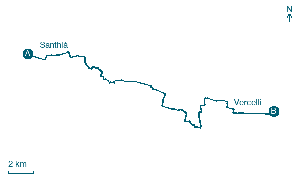
Cover an easy, flat 29 km from Santhià to Vercelli, with no real climbing on the way, passing through Bosafarinera and San Germano Vercellese.
Before leaving Santhià, locate Remains of crenellated wall around the garden of the rectory on the map. It is close to the starting point. On arrival in Vercelli, consider a stop at Monument to Victor Emmanuel II, close to the finish.
Look for these places on the stage map: Bosafarinera, Tenuta Robarello, Cascine Strà, and Campora.
What to see on this stage
History and landmarks
Remains of crenellated wall around the garden of the rectory
< 100 m from the trail as the crow flies
Remains of the city fortifications of the village of Santhià, linear perimeter, angular portion; vertical structures in continuous masonry made of cobblestones in herringbone pattern and brick, with signs of consolidations already present in 1979 (chain heads); brick decorations in dentate style.
Monument to Victor Emmanuel II
< 100 m from the trail as the crow flies
19th-century monument, designed by Ercole Villa, in Vercelli, Italy, 20 m tall, built in bronze.
Nature and landscape
Glicine di Universita' di Vercelli - Via Galileo Ferraris, Vercelli
Monumental tree · 400 m from the trail as the crow flies
Italy’s monumental tree register identifies this specimen as Wisteria sinensis (Sims) Sweet. It records a height of 13 m and a trunk circumference of 350 cm.
Noce satinato di Piazza Sant'Eusebio, Vercelli
Monumental tree · 600 m from the trail as the crow flies
Italy’s monumental tree register identifies this specimen as Liquidambar styracyflua L. It records a height of 32 m and a trunk circumference of 500 cm.
Map · Santhià → Vercelli
Take your walk with you: download Appy
Via Francigena: Santhià → Vercelli. Explore maps, stages and elevation in the app, and plan your train or bus journey.

