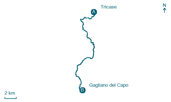
Tricase → Gagliano del Capo
Walking distance 22.5 km
Download Appy for the stage map
Stage information
- Ascent
- 430 m
- Descent
- 406 m
Difficulty: easy
Walking the stage
The final stretch through the deep south of Puglia, past ancient megalithic stones to Gagliano del Capo near the tip of the heel of Italy.
On arrival in Gagliano del Capo, consider a stop at Museum Vito Mele, close to the finish.
Look for these places on the stage map: Tiggiano, Contrada Guardiola, Salignano, and Castrignano del Capo.
What to see on this stage
History and landmarks
Museum Vito Mele
Museum · < 100 m from the trail as the crow flies
21st-century museum, in Castrignano del Capo, Italy.
Castello di Corsano
Castle · < 100 m from the trail as the crow flies
Castle of Corsano. Castle, in Corsano, Italy, designated as Italian national heritage.
Nature and landscape
Quercia vallonea di Bosco Falanite - Fanucchiare, Tricase
Monumental tree · 1.5 km from the trail as the crow flies
Italy’s monumental tree register identifies this specimen as Quercus ithaburensis subsp. macrolepis (Kotschy) Hedge & Yalt. It records a height of 20 m and a trunk circumference of 375 cm.
Quercia vallonea di Bosco Falanite, Tricase
Monumental tree · 1.5 km from the trail as the crow flies
Italy’s monumental tree register identifies this specimen as Quercus ithaburensis subsp. macrolepis (Kotschy) Hedge & Yalt. It records a height of 20 m and a trunk circumference of 350 cm.
Map · Tricase → Gagliano del Capo
Take your walk with you: download Appy
Cammino del Salento Via dei Borghi: Tricase → Gagliano del Capo. Explore maps, stages and elevation in the app, and plan your train or bus journey.

