Fucecchio-Gambassi Terme → Gambassi-San Gimignano
Walking distance 33.5 km
Download Appy for the stage map
Stage information
- Ascent
- 1195 m
- Descent
- 921 m
Difficulty: challenging
Walking the stage
Walk 34 km from Fucecchio-Gambassi Terme to Gambassi-San Gimignano with 1195 m of climbing, passing San Miniato and Catena.
Before leaving Fucecchio-Gambassi Terme, locate Cipresso comune di Piazza La Vergine, Fucecchio on the map. It is close to the starting point.
Look for these places on the stage map: San Miniato, Roffia, La Scala, and Gambassi Terme.
What to see on this stage
History and landmarks
Torre di Matilde
Museum · < 100 m from the trail as the crow flies
Tower of Matilda. 21st-century museum in Romanesque style, in San Miniato, Italy, designated as Italian national heritage, covering 57.0 km².
Most Holy Trinity
Monastery · < 100 m from the trail as the crow flies
Former Augustinian nuns' monastery of the late 1500s, built over the old Podestà's palace whose loggias it kept. Its church is now the Misericordia oratory, with a fourteenth-century Giottesque Madonna fresco; the young Carducci taught in its school in 1858.
Nature and landscape
Cipresso comune di Piazza La Vergine, Fucecchio
Monumental tree · 100 m from the trail as the crow flies
Italy’s monumental tree register identifies this specimen as Cupressus sempervirens L. It records a height of 12 m and a trunk circumference of 115 cm.
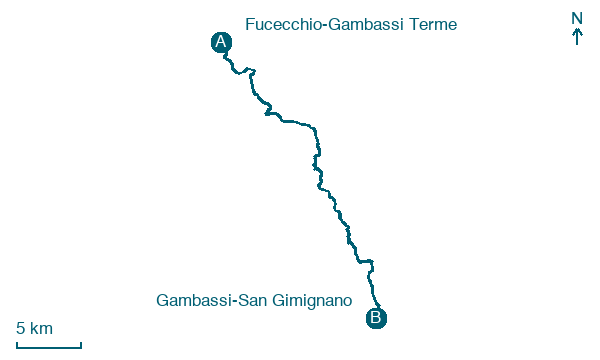
Map · Fucecchio-Gambassi Terme → Gambassi-San Gimignano
Take your walk with you: download Appy
Romea Tuscia: Fucecchio-Gambassi Terme → Gambassi-San Gimignano. Explore maps, stages and elevation in the app, and plan your train or bus journey.

