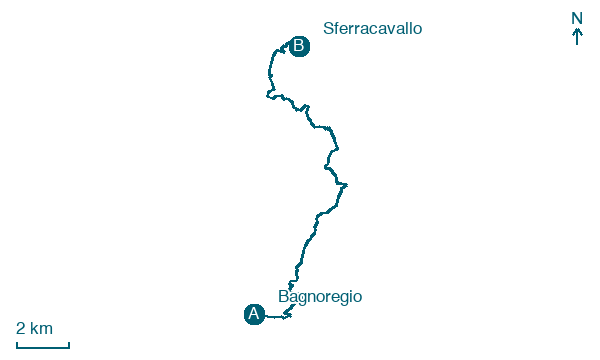
Bagnoregio → Sferracavallo
Walking distance 20.5 km
Download Appy for the stage map
Stage information
- Ascent
- 471 m
- Descent
- 600 m
Difficulty: moderate
Walking the stage
Walk 20 km from Bagnoregio to Sferracavallo, passing Civita di Bagnoregio and Lubriano, with 471 m of climbing along the way.
Before leaving Bagnoregio, locate Co-cathedral of Bagnoregio on the map. It is close to the starting point. On arrival in Sferracavallo, consider a stop at Palazzo Coelli, close to the finish.
Look for these places on the stage map: Civita di Bagnoregio, Lubriano, Canale Nuovo, and Canale Vecchio.
What to see on this stage
History and landmarks
Co-cathedral of Bagnoregio
Cathedral · < 100 m from the trail as the crow flies
A town church raised to cathedral in 1699, after the earthquake of 1695 wrecked the old cathedral in Civita. Its altar facing the congregation is made from a pagan sarcophagus of the second century; the interior is a single nave with stucco decoration.
Palazzo Coelli
Palace · < 100 m from the trail as the crow flies
Palace, in Orvieto, Italy, designated as Italian national heritage, covering 1000.0 km².
Nature and landscape
Grotte della Rupe
200 m from the trail as the crow flies
Cedro dell'Himalaya di Piazza Cahen, Orvieto
Monumental tree · 700 m from the trail as the crow flies
Italy’s monumental tree register identifies this specimen as Cedrus deodara?(D.Don) G.Don. It records a height of 23 m and a trunk circumference of 401 cm.
Map · Bagnoregio → Sferracavallo
Take your walk with you: download Appy
Cammino dell'intrepido Larth: Bagnoregio → Sferracavallo. Explore maps, stages and elevation in the app, and plan your train or bus journey.

