Viterbo → Vignanello
Walking distance 21.7 km
Download Appy for the stage map
Stage information
- Ascent
- 475 m
- Descent
- 462 m
Difficulty: moderate
Walking the stage
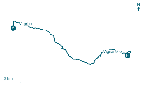
Follow 22 km from Viterbo to Vignanello via La Quercia and Strada Romana, with some ups and downs adding 475 m of ascent.
Before leaving Viterbo, locate Porta Romana, Viterbo on the map. It is close to the starting point.
Look for these places on the stage map: La Quercia, Strada Romana, Canepina, and Vallerano.
What to see on this stage
History and landmarks
Santa Rosa
< 100 m from the trail as the crow flies
A neoclassical church rebuilt in 1850, with a dome added in 1913. It keeps the almost intact body of Saint Rose in a gilded bronze urn of 1699, and on 3 September her festival ends on the square outside with the arrival of the Macchina di Santa Rosa.
Porta Romana, Viterbo
< 100 m from the trail as the crow flies
A plain single-arch gate of tuff and local stone, built in the thirteenth century as the city's southern entrance on the road from Rome. Travellers bound for the Via Francigena passed through it, and the walls beside it are well preserved.
Nature and landscape
Monte Palanzana
Summit · 1.5 km from the trail as the crow flies
Peak, in Province of Viterbo, Italy, at 802 m elevation.
Cedro dell'Himalaya di Via Caduti Nassiria, Vallerano
Monumental tree · 600 m from the trail as the crow flies
Italy’s monumental tree register identifies this specimen as Cedrus deodara (D.Don) G.Don. It records a height of 33.4 m and a trunk circumference of 424 cm.
Map · Viterbo → Vignanello
Take your walk with you: download Appy
Anello Cimino – Il cammino dei Santi Patroni: Viterbo → Vignanello. Explore maps, stages and elevation in the app, and plan your train or bus journey.

