Santa Cristina → Orio Litta
Walking distance 16.1 km
Download Appy for the stage map
Stage information
- Ascent
- 3 m
- Descent
- 13 m
Difficulty: easy
Walking the stage
Cover 16 km from Santa Cristina to Orio Litta on gentle ground, with just 3 m of climbing overall.
Before leaving Santa Cristina, locate Monastero di Santa Cristina on the map. It is close to the starting point.
Look for these places on the stage map: Cascina Pistoia, Camporinaldo, Mostiola, and Castellazzo.
What to see on this stage
History and landmarks
Monastero di Santa Cristina
Monastery · 200 m from the trail as the crow flies
Monastery of Santa Cristina. Monastery, in Santa Cristina e Bissone, Italy, designated as Italian national heritage.
Castello di Santa Cristina e Bissone
Castle · 300 m from the trail as the crow flies
Castle of Santa Cristina e Bissone. Castle, in Santa Cristina e Bissone, Italy, designated as Italian national heritage.
Nature and landscape
Platano comune di Via Dante Alighieri Angolo Via Fiume, Santa Cristina E Bissone
Monumental tree · 100 m from the trail as the crow flies
Italy’s monumental tree register identifies this specimen as Platanus acerifolia (Aiton) Willd. It records a height of 26 m and a trunk circumference of 490 cm.
Cedro del Libano di Via Cusano Visconti, Chignolo Po
Monumental tree · 200 m from the trail as the crow flies
Italy’s monumental tree register identifies this specimen as Cedrus libani A.Richard. It records a height of 30 m and a trunk circumference of 480 cm.
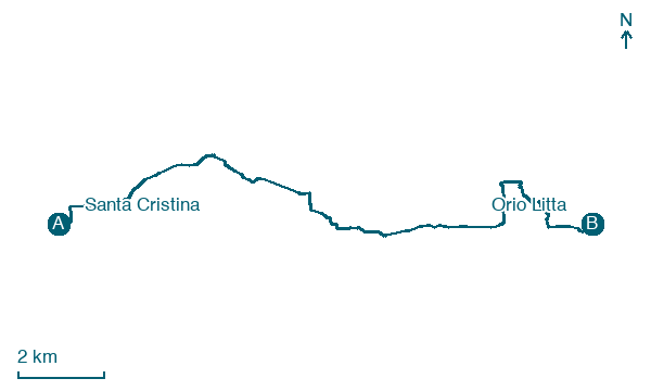
Map · Santa Cristina → Orio Litta
Take your walk with you: download Appy
Via Francigena: Santa Cristina → Orio Litta. Explore maps, stages and elevation in the app, and plan your train or bus journey.

