Prato → Pistoia
Walking distance 27.1 km
Download Appy for the stage map
Stage information
- Ascent
- 22 m
- Descent
- 12 m
Difficulty: moderate
Walking the stage
Enjoy an easy 27 km walk from Prato to Pistoia, with only 22 m of climbing, passing Filettole and Riva di Bagnolo.
Before leaving Prato, locate Palace on Piazza Duomo 56, 57, 58, 59, 60, 61 on the map. It is close to the starting point.
Look for these places on the stage map: Filettole, Riva di Bagnolo, Santomato, and Pontenuovo.
What to see on this stage
History and landmarks
Albergo Giardino
Palace · < 100 m from the trail as the crow flies
load-bearing walls: stone and brick (core), stone (courses and decorations)
Palace on Piazza Duomo 56, 57, 58, 59, 60, 61
Cathedral · < 100 m from the trail as the crow flies
Load-bearing walls: stone and brick (core); stone (courses and decorations)
Nature and landscape
Cipresso comune di La Rocca, Montemurlo
Monumental tree · < 100 m from the trail as the crow flies
Italy’s monumental tree register identifies this specimen as Cupressus sempervirens L. It records a height of 20 m and a trunk circumference of 265 cm.
Cedro azzurro dell`Atlante di La Rocca, Montemurlo
Monumental tree · < 100 m from the trail as the crow flies
Italy’s monumental tree register identifies this specimen as Cedrus atlantica (Endl.) Manetti ex Carriere var. glauca. It records a height of 20 m and a trunk circumference of 405 cm.
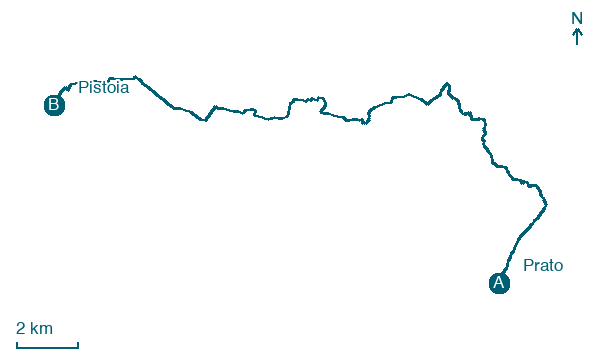
Map · Prato → Pistoia
Take your walk with you: download Appy
Cammino di San Jacopo: Prato → Pistoia. Explore maps, stages and elevation in the app, and plan your train or bus journey.

