Poggio Sannita → Belmonte del Sannio
Walking distance 8.6 km
Download Appy for the stage map
Stage information
- Ascent
- 226 m
- Descent
- 99 m
Difficulty: easy
Walking the stage
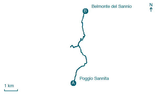
Walk 9 km from Poggio Sannita to Belmonte del Sannio, with 226 m of climbing along the way, passing through Civitanova del Sannio and Colle Rosso.
On arrival in Belmonte del Sannio, consider a stop at Roverella di Chiesa di San Rocco, Belmonte del Sannio, close to the finish.
Look for these places on the stage map: Civitanova del Sannio, Macchie, Scalzavacca, and Sente (primo).
What to see on this stage
History and landmarks
Palazzo Lalli
Palace · 1.7 km from the trail as the crow flies
In the building, there are three residential units.
Palazzo Martino
Palace · 1.7 km from the trail as the crow flies
In the building, there are four residential units.
Nature and landscape
Roverella di Masseria Belladonna - Belladonna, Agnone
Monumental tree · < 100 m from the trail as the crow flies
Italy’s monumental tree register identifies this specimen as Quercus pubescens Willd. It records a height of 21 m and a trunk circumference of 285 cm.
Roverella di Chiesa di San Rocco, Belmonte del Sannio
Monumental tree · 500 m from the trail as the crow flies
Italy’s monumental tree register identifies this specimen as Quercus pubescens Willd. It records a height of 21 m and a trunk circumference of 499 cm.
Map · Poggio Sannita → Belmonte del Sannio
Take your walk with you: download Appy
Cammino delle Chiese campestri: Poggio Sannita → Belmonte del Sannio. Explore maps, stages and elevation in the app, and plan your train or bus journey.

