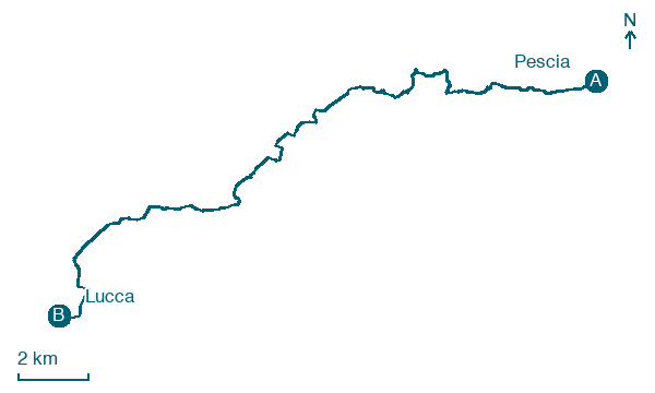
Pescia → Lucca
Walking distance 26.3 km
Download Appy for the stage map
Stage information
- Ascent
- 8 m
- Descent
- 24 m
Difficulty: easy
Walking the stage
Enjoy an easy 26 km walk from Pescia to Lucca, with only 8 m of climbing, passing Ponte all'Abate and Sant'Andrea in Caprile.
On arrival in Lucca, consider a stop at Fountain of Piazza Antelminelli, close to the finish.
Look for these places on the stage map: Ponte all'Abate, Sant'Andrea in Caprile, Ai Santucci, and Monte San Quirico.
What to see on this stage
History and landmarks
Palazzo Mazzarosa
Palace · < 100 m from the trail as the crow flies
Palace, dedicated to Mazzarosa family, in Lucca, Italy, designated as Italian national heritage.
Fountain of Piazza Antelminelli
< 100 m from the trail as the crow flies
Fountain, dedicated to House of Antelminelli, in Lucca, Italy, designated as Italian national heritage.
Nature and landscape
Leccio di San Gennaro - Via di Castello, Capannori
Monumental tree · < 100 m from the trail as the crow flies
Italy’s monumental tree register identifies this specimen as Quercus ilex L. It records a height of 18 m and a trunk circumference of 515 cm.
Platano comune di Centro Storico - Via del Fosso, Lucca
Monumental tree · < 100 m from the trail as the crow flies
Italy’s monumental tree register identifies this specimen as Platanus acerifolia (Aiton) Willd. It records a height of 30 m and a trunk circumference of 360 cm.
Map · Pescia → Lucca
Take your walk with you: download Appy
Cammino di San Jacopo: Pescia → Lucca. Explore maps, stages and elevation in the app, and plan your train or bus journey.

